Study Sites & Design: Regional Site Network
Background
Long-term monitoring of climate and vegetation is one of the most important aspects of the LTER Network. BNZ LTER specific sites, referred to as BNZ ‘core sites’, were established initially in the 1980s (during LTER I) to address the conceptual theme of boreal forest succession. It was hypothesized that succession in floodplains (after fluvial disturbance) and uplands (after fire) would follow a predictable development of hardwood and then coniferous stands, with black spruce stands becoming the terminal endpoint until disturbance reset the successional trajectory.
Over the past few decades, multiple studies led by BNZ LTER members have suggested that boreal forest succession following disturbance in both Interior Alaskan floodplains and upland forests is more complicated than defined above. Collectively, these studies indicate that the timing and severity of disturbance, herbivory, pre-disturbance plant composition, and site characteristics strongly interact to allow for shifts in both community composition and successional trajectories. This suggests that the original conceptual framework used for establishing the BNZ core sites does not capture the range of variability in post-disturbance vegetation succession and ecosystem processes in Alaskan boreal forests.
Establishment of a regional network of sites
We recognized the need to shift away from monitoring floodplain and upland successional dynamics as was initially defined several decades ago, but still maintain the integrity of this long-term monitoring record. To meet this challenge, we expanded our core measurements to an extensive, regional set of sites (Regional Site Network; RSN).
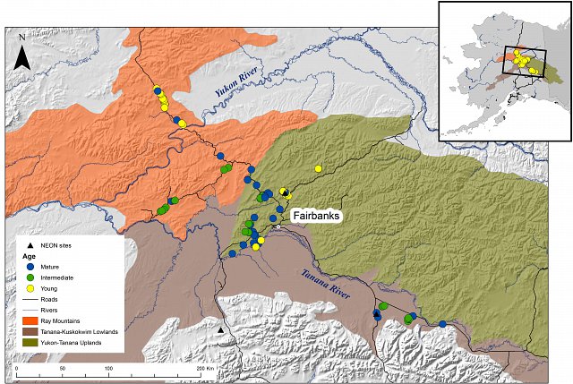
This RSN focuses on black spruce, which is the most extensive forest type in Interior Alaska and is experiencing radical disturbance-driven changes in successional dynamics. For this network we developed the following experimental design: monitoring of vegetation composition and productivity, permafrost status (soil temperature and moisture), and climate (air temperature, precipitation, and radiation) in black spruce stands of various ages (time-since-fire) and site drainage regimes across three ecoregions.
Within each ecoregion, we selected stands in three age classes (young [0-15 years], intermediate [40-60] and old [>80]) that cover gradients in site drainage (soil moisture, permafrost status, soil texture, and topographic position) and post-fire tree densities of spruce and hardwoods. Detailed information on the design of this site network can be found in the Research Site Installation Methods.
Regional site network Ecoregions
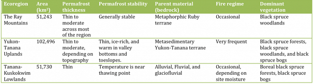
A large proportion of the boreal forest within Interior Alaska situated between the Yukon River and the Alaska Range falls within three ecoregions: the Ray Mountains, the Tanana-Kuskokwim Lowlands, and the Yukon-Tanana Uplands. All three ecoregions have a strongly continental climate with cold winters and warm summers, discontinuous permafrost, and prevalent forest fires. However permafrost temperature, summer moisture, and dominance of forest fires differ between these ecoregions.
Check out an interactive map of the BNZ LTER Regional Site Network. For more information about this map contact Jamie Hollingworth.