Study Sites & Design: Bonanza Creek Experimental Forest
Credit: Roger Ruess
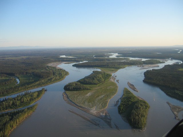
The Bonanza Creek Experimental Forest (BCEF) was established in 1963 and consists of typical vegetation and landforms in Interior Alaska. It includes a mosaic of forested and non-forested vegetation types corresponding to four broad topographic zones: upland hills and ridges, lowland toeslopes and valley bottoms, old Tanana River terraces, and the active floodplain.
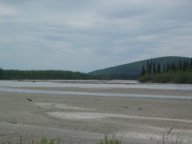
A wide array of research has been conducted in the BCEF since the 1950s (e.g., effects of red squirrel foraging on white spruce cone and seed production, nutrient relationships in birch and black spruce stands, monitoring of insect and pathogen outbreaks). In 1987, BCEF joined the LTER program to address successional processes in the boreal forest of Interior Alaska. The LTER research program at BCEF tests hypotheses in two successional sequences: primary succession on the floodplain of the Tanana River (six successional stages with three replicates per stage) and secondary succession following wildfire in upland forests (four successional stages). The Tanana River is the largest tributary of the Yukon River, and is bordered by the Alaska Range to the south and the Yukon-Tanana Upland physiographic province to the north.
Credit: Jeremy Jones
Successional stages and turning points
We selected "turning points" in the succession sequences where critical changes in ecosystem structure are accompanied by functional changes, which have far-reaching effects on ecosystem development. At six turning points in the floodplain succession and three turning points in the upland succession, three replicates of experimental plots were established to follow the natural changes occurring in ecosystem structure and function.
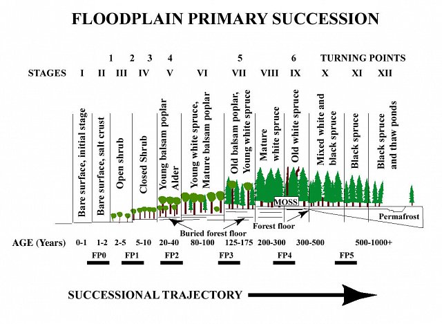
The trajectory of succession is sensitive to environment, propagule availability, legacies associated with pre-fire vegetation, and disturbance severity. Primary succession predominates in the active floodplain. After initial establishment, competition, facilitation, and herbivory interact to drive succession. Ecosystem controls change at key turning points, where a shift in the dominance of plant functional types radically alters the physical and chemical environment that govern ecosystem processes and disturbance probability. Some key turning points include (1) a shift to balsam poplar dominance, where changes in productivity potential and litter chemistry enhance NPP and nitrogen cycling rates and (2) a shift to white spruce dominance, where mosses grow rapidly, nutrient cycling rates are reduced, and fire probability increases due to the production of resinous fuels that dry quickly.
Secondary succession is the rule in the uplands. Self-replacement, in which the pre-fire tree species returns to dominance shortly after fire, generally occurs in extreme environments whereas succession with multiple stages is more common in intermediate sites. Late-successional conifers establish during the initial 1-2 decades after fire, but their establishment success is sensitive to various environmental variables (e.g., post-fire soil organic layer depth, understory species composition, etc.). However, variations in fire frequency or severity can alter post-fire vegetation composition and thus the successional trajectory of these areas.
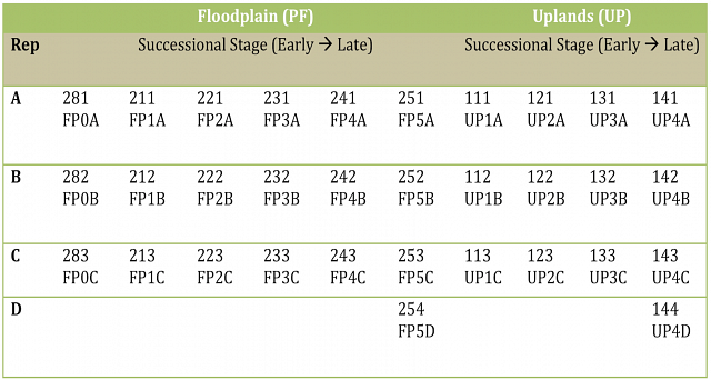
Study sites at BCEF are named according to the habitat, successional stage the site was at when the site was established, and the replicate. There are two main naming schemes. In the first scheme the site is described numerically. In the second naming scheme the sites are coded according to the following scheme: Habitat (FP=Floodplain, UP=Upland), successional stage (numeric), replicate (A-C).
At each BCEF site, a 50x60 m permanent "control plot" was established. Within each control plot:
- 20 vegetation plots are sampled. Each vegetation plot consists of a 1 m2 plot for measurement of herb, lichen, moss, and low shrub cover estimates and a 4 m2 plot for measurement of shrubs and tree seedlings.
- All trees and shrubs having a breast height diameter of 2.5 cm or larger are tagged and mapped. Ten trees of each species within the reference stand are also equipped with band dendrometers for measuring annual diameter growth at breast height.
- In young successional stands the vegetation plots are monitored every two years and in mature types every five years.
Litter trays have been placed in each reference stand and seed traps in one of each of the eight successional stages. At four points around the perimeter of each reference stand the forest floor and mineral soil profile was described and sampled using standard procedures. Bulk samples of both materials were obtained for physical and chemical analysis. These assessments are repeated at 10-year intervals.
Activities within the area interfering with long-term research plots are restricted through the lease agreement. Research development within the area is managed by BNZ staff. Permission to conduct research can be obtained by contacting the lead principal investigators or the Site Manager, Jamie Hollingsworth.