Effects of Climate Change
Section I. Direct effects of climate change on ecosystems and disturbance regimes
Ecosystem responses to climate warming are modulated by strong feedbacks between ecosystem structure and disturbance regimes as well as the interaction of multiple disturbances across the landscape. For example, sensitivity of net primary production to warming appears to be more a function of soil moisture and soil nutrient availability, than to temperature per se. Vegetation has strong influences on soil moisture and thermal properties that regulate permafrost stability, interactions that affect and are affected by fire frequency and severity.
To expand our current understanding, we are focusing on quantifying patterns in the response of both ecosystems and disturbance regimes to climate change across spatial and temporal scales. This research is organized around two hypotheses:
Hypothesis 1a: Climate change influences ecosystem structure and function at multiple temporal scales through effects on site conditions, key species and vegetation community types, transforming landscape structure and heterogeneity.
Hypothesis 1b: Disturbance regimes that have shaped the boreal forest for millennia are changing due to increases in mean annual temperature, the length of the snow-free period, and the incidence of drought.
Hypothesis 1a: Climate change influences ecosystem structure and function at multiple temporal scales through effects on site conditions, key species and vegetation community types, transforming landscape structure and heterogeneity.
Task 1: Quantify the climate sensitivities of vegetation communities across multiple temporal and spatial scales, with an emphasis on relationships among plant species diversity, life history and functional traits, and productivity.
The BNZ Regional Site Network provides a hierarchical framework for long-term monitoring of community processes, their sensitivity to changing climate, and their effects on ecosystem function across spatial and temporal scales. We have complete vascular and non-vascular diversity data at all Regional Site Network sites. Net primary production is being measured at a variety of scales using both field and remote sensing techniques.
In addition, we are monitoring the phenology of approximately 70 plant species across multiple sites, including recently introduced species. We are combining these measurements with historical records based on herbarium specimens to evaluate how individual species will respond to changes in climate such as changes in season length, mean temperature, and amount and timing of precipitation.
Finally, we are quantifying a suite of plant functional traits to provide a mechanistic framework for explaining shifts in phenology and community processes across environmental conditions captured by the Regional Site Network.
Task 2: Determine the direct and interactive effects of climate sensitivity vs. intrinsic factors on wide-spread patterns of browning in the boreal forest.
Here, we are combining long-term records of tree growth and mortality from BNZ plots and other statewide datasets in productive, floodplain forests with our recently initiated Regional Site Network (RSN) in upland forests to disentangle intrinsic vs. extrinsic drivers of forest productivity. Our approach integrates monitoring data with tree-ring records and demographic reconstruction of stand mortality to provide a basis for interpreting satellite records of changing forest productivity.
Hypothesis 1b: Disturbance regimes that have shaped the boreal forest for millennia are changing due to increases in mean annual temperature, the length of the snow-free period, and the incidence of drought.
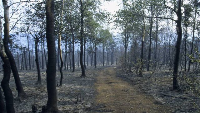
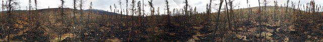
Task 3: Examine the relationship between climate and the spatial heterogeneity of fires (variation in burn area and severity, fragmentation of burn scars, composition of unburned islands) and determine what parts of the landscape are most vulnerable to reburn and vegetation change.
Our goal is to better understand where and when Alaska conifer forests are vulnerable to conversion to deciduous forest following wildfire by examining the role of a suite of fire regime characteristics, including past and current forest fragmentation, topographic position, fire seasonality, and fire return interval.
Landscape fragmentation is a legacy of past disturbance (both wildfire- and human-caused), but also influences current fire behavior and the spatial heterogeneity of vegetation trajectories we see on the landscape today. LANDSAT imagery from the 1980s to present will be used to examine how post-fire vegetation has been driven by various components of the fire regime.
We use daily MODIS hotspot locations to examine how seasonality within a burn perimeter influences post-fire vegetation on similar landscape types and are using plot-level data from two very different large fire years (2004, that burned late in the growing season and 2015, that burned early in the growing season) along with archived post-fire plot-level data dating back to 1950, to ground-truth pre- to post-fire conifer:hardwood ratios and assess whether there was significant change in post-fire vegetation that cannot be explained by topography and relay succession, indicating a true state-change as a result of climate-induced changes to the fire regime. Based on information from field and remote sensing data, we will create maps of landscape vulnerability and determine the landscape components most susceptible to change.
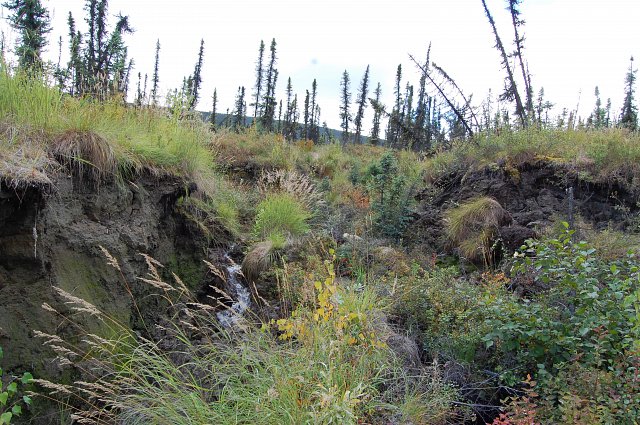
Task 4: Examine how interactions between climate, fire severity, and landscape characteristics govern patterns of permafrost thaw and subsequent recovery.
Discontinuous permafrost in Interior Alaska is heterogeneous at multiple scales (i.e., broad variations in permafrost thickness, finer scale distributions of ice content and closed and open taliks), and our ability to predict changes in permafrost regimes requires more information on this heterogeneity and how it interacts with ecological and hydrological systems.
We are using a combination of vertical ground temperature monitoring, electrical resistivity tomography (ERT), seasonal thaw depth measurements, and permafrost coring to investigate spatial variation in permafrost thickness, spatial extent, and soil properties and ice content across a subset of RSN sites encompassing a range in vegetation cover, fire history, soil type, and geomorphology.
Of primary interest is how fire severity influences both short- and long-term rates of thaw. We include sites that burned during the extreme fire seasons of 2015 and 2004, using a space-for-time substitution to examine the spatial variation in thaw depth and subsidence following fire. These data will be analyzed using understanding gained from Task 3. Within a single location, repeat ERT measurements can provide insight into the sustained impact of climatic variation, fire disturbance, and post-fire vegetation recovery on permafrost stability and dynamics. We are using these approaches to monitor changes in permafrost structure that occurred following a record flood in 2014 that led to large increases in active layer thickness.
Together, the proposed research will allow us to understand where and when permafrost is most vulnerable to degradation, what landscape characteristics (vegetation, substrate composition and properties, geomorphology, aspects of ground or stream hydrology) have the potential to alter the sensitivity of permafrost to climate, as well as what controls the spatial nature of permafrost recovery following disturbance. We will then use the thermal and geophysical data in combination with GIS techniques to analyze permafrost distributions and identify which areas are most vulnerable to thaw and thermokarst development. Overlays with fire perimeter maps will allow us to make inferences about relationships between fire history and contemporary permafrost regimes.